令和6年能登半島地震(M7.6)のSAR画像解析による地盤変動の特徴
Ground deformation due to the 1 Jan 2024 Noto-Hanto Earthquake (M7.6) captured by SAR image analysis
2024.01.09
福島 洋(東北大学災害科学国際研究所)
石村大輔(東京都立大学都市環境学部)
髙橋直也(東北大学大学院理学研究科 地学専攻)
Yo Fukushima, Daisuke Ishimura, Naoya Takahashi
2024年1月1日に能登半島で発生した地震(M7.6)について、SAR(合成開口レーダ)画像を用いた地盤変動の解析を実施しました。以下に解析の概要と結果を示します。
This page
contains the results of SAR data analysis of the 1Jan. 2024 Noto-Hanto Earthquake (M7.6).
使用データ:だいち2号により撮像されたSAR画像
Used data:
SAR images acquired by the ALOS-2 satellite
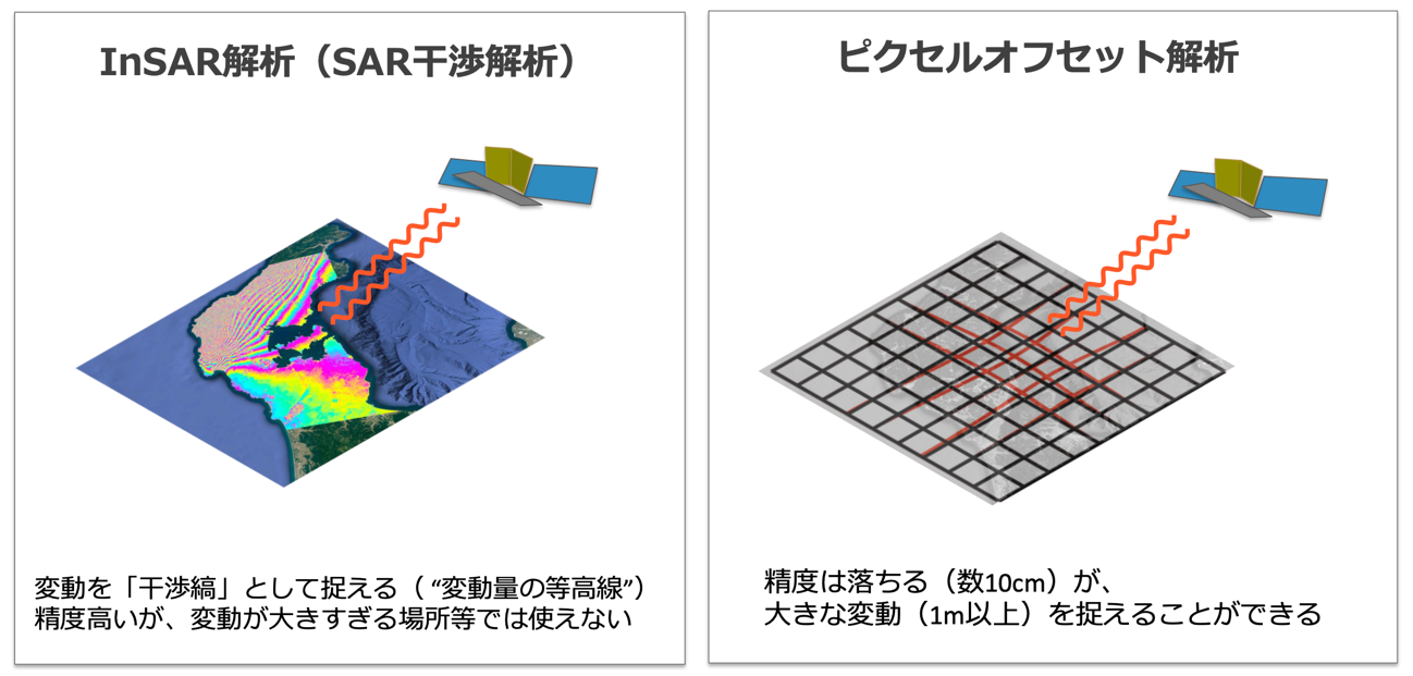
解析手法:InSAR(SAR干渉)解析およびピクセルオフセット解析
Used
method: SAR interferometry and pixel-offset analyses
[SAR干渉解析結果 Interferograms]
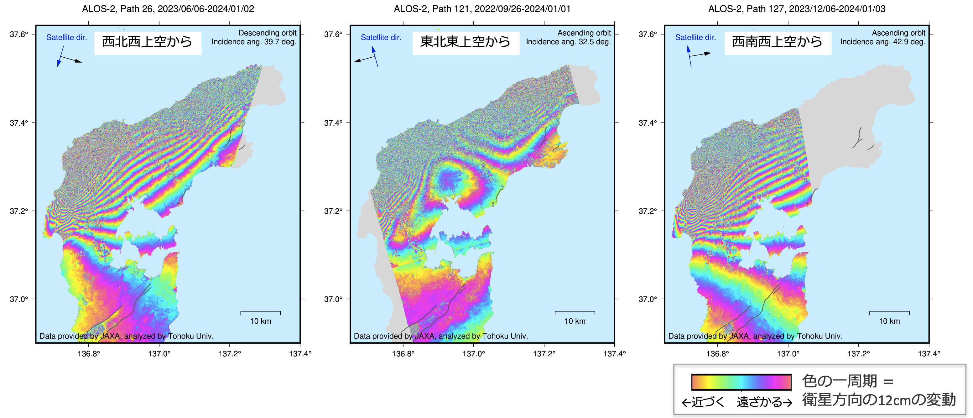
半島北岸側は、非干渉のため変動追跡できません。非干渉の原因には、変動量甚大・建物の倒壊や大変形・地盤変状・積雪等があります。その南側、能登半島全体にわたり、いくつもの縞がありますが、これが今回の地震を起こした主断層のすべりによる変動です。また、広域の図からはわかりませんが、より局所的には、副次的な地表断層のずれ・地すべり・地盤沈下等に伴う縞の変化があります。
Signals on the northern part are decorrelated due to large crustal deformation, heavy damages, etc. The fringes identifiable on the whole Noto peninsula are due to the faulting of the M7.6 earthquake. In a smaller scale, we can observe small fault ruptures, landslides, and land subsidence.
analyses
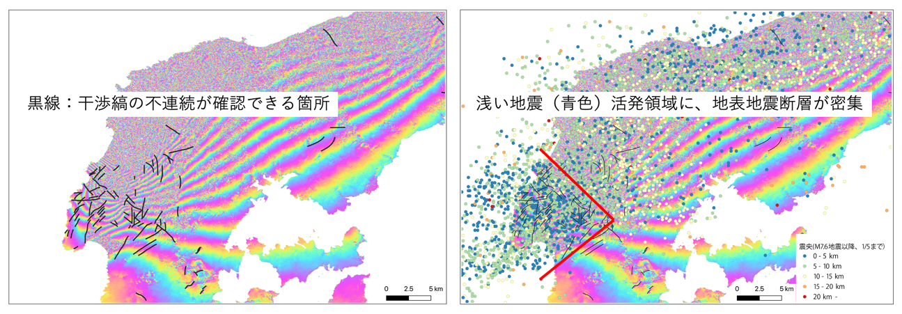
干渉画像から確認できる変位不連続の多くは、副次的に発生した地表の断層のずれに対応すると考えられますが、そのような副次的な地表地震断層のずれは能登半島の西側付近に密集していました。また、その密集域は、浅い余震の発生域によく対応していました。
Most of the displacement discontinuity traces identified in the interferogram are probably due to triggered shallow slips of secondary faults. Such discontinuity traces are clustered in the western part, where active seismicity is also observed.
analyses
[ピクセルオフセット解析結果 Pixel-offset analysis]

能登半島の北西端において、最大4m程度の衛星に近づく方向の変位が確認できます。
Displacements of up to about 4 meters were observed.
analyses
[上下方向・東西方向への分解(2.5次元解析結果)]
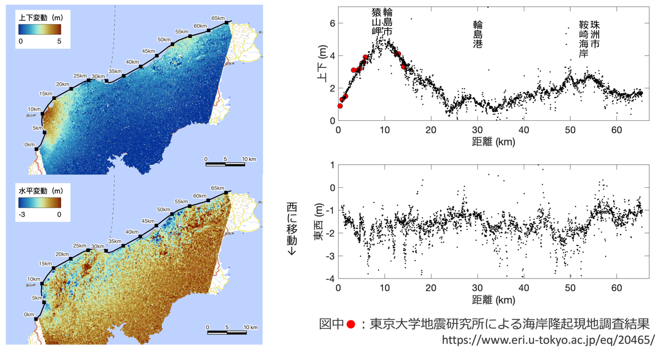
ピクセルオフセット解析で得られた二方向からの変動を準上下・準東西方向の成分に分解しました。正確な上下・東西方向からは、それぞれ、11度と3度ずれた方向の成分ですが、上下・東西成分とみなして問題ない程度のずれです。
海岸沿いの隆起量分布からは、輪島市の猿山岬付近で4.9m程度、珠洲市の鞍崎海岸付近で2.7m程度の隆起があったとの結果になりました。東京大学地震研究所から公表されている現地調査とよく整合しています。なお、本結果は暫定的なものであり、今後改定の可能性があります。
The displacements measured from the pixel-offset analysis were decomposed into quasi-vertical and quasi-EW displacements. The vertical displacements shows uplift of the northern coast. The maximum was 4.9 meters. The uplift distribution is consistent with the survey result reported in the website of the Earthquake Research Institute of the University of Tokyo.
analyses
[謝辞]
本成果は、JAXAが主体となって実施している地球観測衛星を用いた防災利用検証実験の一環として、地震予知連絡会SAR解析ワーキンググループ(事務局:国土地理院)の活動を通して得られたものです。気象庁の震源データを使用させていただきました。SAR干渉解析とSARピクセルオフセット解析には、それぞれRINCとISCEを使用させていただきました。
These
results were obtained through the activity of the SAR analysis working group of
the Coordinating Committee for Earthquake Prediction, Japan. Earthquake
catalogue was obtained from the JMA. We used RINC and ISCE for SAR
interferometry and pixel offset analysis, respectively.
[データについて]
-
本解析で用いたALOS-2衛星のSARデータは、現在、JAXAのウェブサイトより公開されており、公共利用・研究利用目的の利用が可能です。
https://www.eorc.jaxa.jp/ALOS/jp/dataset/alos_open_and_free_j.htm
-
本解析から得られたSAR干渉画像、ピクセルオフセット結果、上下・東西成分への分解結果のGoogle
Earth形式のファイル、北側沿岸沿いの隆起分布・東西変位分布のデータについては、以下からアクセス可能です。
Fukushima, Y., D. Ishimura, and N. Takahashi
(2024) Ground deformation analysis results using ALOS-2 SAR data for the 1
January 2024 Noto-Hanto, Japan, earthquake, https://doi.org/10.6084/m9.figshare.24960711.
[参考ウェブサイト・文献]
- 国土地理院「令和6年(2024年)能登半島地震に関する情報」
https://www.gsi.go.jp/BOUSAI/20240101_noto_earthquake.html
- 国土地理院「干渉SARを知る」
https://www.gsi.go.jp/uchusokuchi/sar_info.html
- 熊本地震での副次的な断層出現事例
Fujiwara, S., Yarai, H., Kobayashi, T. et al. Small-displacement
linear surface ruptures of the 2016 Kumamoto earthquake sequence detected by
ALOS-2 SAR interferometry. Earth Planets Space 68, 160
(2016). https://doi.org/10.1186/s40623-016-0534-x
Return to
Yo Fukushima’s Top Page